| Commonwealth of Pennsylvania | |||||
| |||||
| Nickname(s): Keystone State; Quaker State; Coal State; Oil State; State of Independence | |||||
| Motto(s): Virtue, Liberty and Independence | |||||
 | |||||
| Official language(s) | None (English, de facto) | ||||
| Spoken language(s) | English 91.6% Spanish 3.1% Pennsylvania Dutch | ||||
| Demonym | Pennsylvanian | ||||
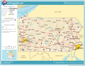
| Capital | Harrisburg | ||||
| Largest city | Philadelphia | ||||
| Largest metro area | Delaware Valley | ||||
| Area | Ranked 33rd in the U.S. | ||||
| - Total | 46,055 sq mi (119,283 km2) | ||||
| - Width | 280 miles (455 km) | ||||
| - Length | 160 miles (255 km) | ||||
| - % water | 2.7 | ||||
| - Latitude | 39°43′ N to 42°16′ N | ||||
| - Longitude | 74°41′ W to 80°31′ W | ||||
| Population | Ranked 6th in the U.S. | ||||
| - Total | 12,702,379(2010.) | ||||
| - Density | 283.9/sq mi (109.6/km2) Ranked 11th in the U.S. | ||||
| - Median income | US$48,562 (26th) | ||||
| Elevation | |||||
| - Highest point | Mount Davis 3,213 ft (979 m) | ||||
| - Mean | 1,099 ft (335 m) | ||||
| - Lowest point | Delaware River 0 ft (0 m) | ||||
| Before statehood | Province of Pennsylvania | ||||
| Admission to Union | December 12, 1787 (2nd) | ||||
| Governor | Tom Corbett (R) | ||||
| Lieutenant Governor | Jim Cawley (R) | ||||
| Legislature | General Assembly | ||||
| - Upper house | State Senate | ||||
| - Lower house | House of Representatives | ||||
| U.S. Senators | Bob Casey, Jr. (D) Pat Toomey (R) | ||||
| U.S. House delegation | 12 Republicans, 7 Democrats | ||||
| Time zone | Eastern: UTC-5/-4 | ||||
| Abbreviations | PA Penn. or Penna. US-PA | ||||
| Website | pa.gov | ||||

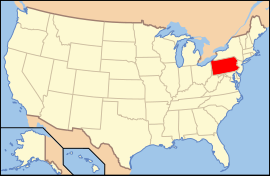
The Commonwealth of Pennsylvania is a U.S. state that is located in the Northeastern and Mid-Atlantic regions of the United States. The state borders Delaware and Maryland to the south, West Virginia to the southwest, Ohio to the west, New York and Ontario, Canada, to the north, and New Jerseyto the east. The state's four most populous cities are Philadelphia, Pittsburgh, Allentown, and Erie. The state capital is Harrisburg.
Pennsylvania has 51 miles (82 km) of coastline along Lake Erie and 57 miles (92 km) of shoreline along the Delaware Estuary. As of the 2000, and 2010census, Pennsylvania has one of the largest European American populations and a strong African American population.